Altitude: 4647 meters
Geographic location: Central Andes of Chile
Latitude: 33 ° 43 36 S
Longitude: 70 ° 03 44 O
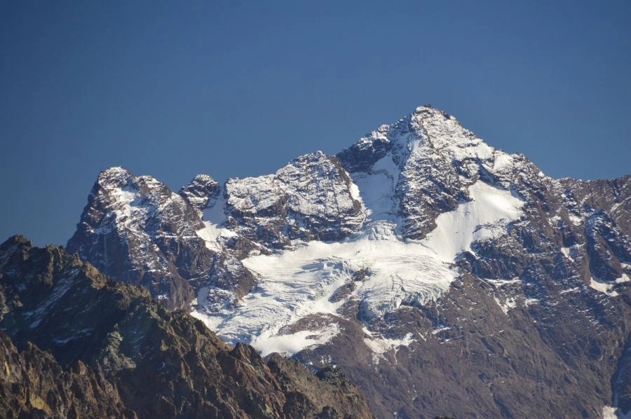
Penetrating through the Cajon del Rio Volcan. just north of Lo Valdes, sharp highlights the pointed peaks of Cerro Morado.
This mountain is a kind of blazon of the region, and as none attracted the desire of climbers. For its beauty and its easy access, it had twenty attempts before the end of 1933.
The main summit is the northern, although from Morado National Park, south of the mountain, the, lowest southern summit 4,490 meters above sea level, stands more upright a magnificent dark rocky triangle.
First ascent: On the northeast or Route Yeso, was conducted by Otto Pfenniger and Sebastian Krückel on 23 December 1933. Vertiente first ascent of the Southeast: Carlos Piderit and Jorge Silva, on March 4, 1943.
right time. Depending on conditions, from October to April ..
Difficulty. III +. High mountain. Quite difficult. Rock steps that sometimes require use of rope (II-III). Ice-snow slopes up to 50 degrees. Domain use the ice ax, crampons and technical assurance, and self-arrest in snowfields.
Equipment. Camping. High mountain shelter. High mountain boots. Piolet ice ax and hammer. Crampons. Rope. auxiliary rope (8-12 meters / 6-8 mm.). Helmet. Harness. By roped two or three: 2 tapes (2-4 meters), 2 snow stakes two ice screws (optional).
Access. From Santiago, the Maipo Canyon road is 70 kilometers to San Gabriel paved and gravel roads to reach another 20 hamlet of Baños Morales (1820 meters).
The tour.
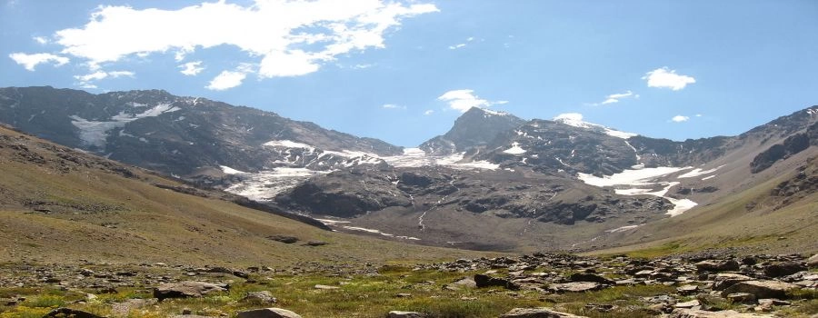
Follow Baños Morales eastward footprint serving the mining operations, tracing parallel to the north bank of the River Volcano. After a couple of hours of walking and slight rise, surrounding the Massif Rubilla, the trail turns north, going along the left bank of the Cajon del Morado (Las Arenas), as the landscape is filled icy peaks. Another hour walk left front and under the south face of Cerro Arenas, an enclave at 2,300 meters above sea level. Here you can sometimes get a vehicle with four-wheel drive, but in spring it is rare. Also here you can spend the night. When not frozen, the water is obtained from the neighboring Estero Morado. Two hours march north left under the flank of Mount Union, whose hillside and there is a low-altitude mining pique (not to be confused with those that are before more height). Until this place, 2,950 meters, also comes a very tough road vehicle, exceptionally passable. Trace the stream that falls from the northwest, from Morado, and another hour driving reach the glacier lagoon in the small high valley formed by the Morado, the Mirador de Morado, and the Union (3200 meters, good place camping).
Ascent The first part of the route is not perfectly clear. Runs through the wide rocky cliff that drops to the right of the cascade of seracs falling into the lagoon. Generally it follows the center a large patch of snow shaped and about eight hundred meters long (this view changes with the season), but other cordadas opt for a large snow chute further to the left. Both alternatives present some complications rock, especially in the upper part of the wall. Recommended rope and insurance. Beware of falling stones. Remember or mark the exit to find the path to decline. In three or four hours the slope declines and reaches outside the Morado Glacier, possible camp (3900 meters). One hour drive north ice left on the flat part of the glacier, where you can also camp (about 4,150 meters). In the end there are also different variants cone. It is usual to surround the rocky spur that falls from the top. On the left (west) is shorter but steeper and furrowed by some seracs; on the right, crossing and ascent ice inclined, alternative longer but less eventful than the last. Five or six hours. Sometimes the glacier is very cracked. Unevenness of the route: 1,500 meters. total climb of the tour: 2.800 meters.
Itinerary
In four or five days:
1. Santiago-Camp "Las Arenas"
2. Camp "Las Arenas" -Campo high
3. Field-Campo high-top high
4. High-Santiago Campo.
Source: Cumbres de Chile
 Portugues
 English