Hornopiren National Park. Hornopirén - CHILE
Direccion:
Region de los Lagos The Hornopiren National Park was created in 1988 with an area of 48,232 hectares. It is administered by CONAF and is located east of the town of Hornopiren, in southern Chile.
Location:
The town of
Hornopiren is located in the municipality of Hualaihue, Province of Palena, Los Lagos Region.
Its main access corresponds to the "austral highway" that begins to the south of the city of
Puerto Montt, the regional capital located in the province of Llanquihue. The distance between both urban centers is 107 km, which are traveled on an asphalt surface at the beginning and then gravel in 3 hours approximately, time that includes crossing by ferry boat through the Reloncavi Estuary (30 minutes), between the coves La Arena (province of Llanquihue) and Puelche (province of Palena).
There are two bus companies that cover the Puerto Montt-Hornopiren section. Buses can take up to 5 hours to arrive at destination, since they stop several times to take and leave passengers at certain points along the route.
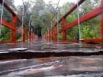
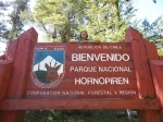
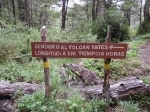
The administration office of the National Park is located in the city of Hornopiren, its street address Libertador Bernardo OHiggins s / n, next to the central square, from where the only access road to this protected wild area begins . The first half of this can be traveled in a motor vehicle; the other half must be concluded on foot. The first part follows the main gravel road Lib. Bernardo OHiggins 11 km north to its end, in the sector of Chaqueihua Alto, which takes about 20 minutes in a double-traction vehicle. Then there is a rough trail of 7 km that crosses 4 private plots on its way to the entrance of the National Park, where visitors are greeted by a huge wooden sign that welcomes them.
Characteristics of the area.
Climate:
In the Park there are temperate rainy, mountain and ice climates due to the height effect, depending on the observation area. In the recreational sectors abundant rains predominate, where the average annual rainfall reaches 2,500 mm, and may exceed 4,000 mm. The average temperature fluctuates between 9 and 12 degrees Celsius, having between 50 and 150 days with frosts a year, even in summer. The relative humidity of the air is constant on the coast, exceeding 80.
Due to the large accumulation of snow and ice (more than a meter thick) in the recreation areas during the winter and spring months, the Park is normally closed to the general public between July and November for security reasons.
Geography:
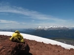
The park is part of the Andes mountain chain, whose geography characterized by high and sharp mountains and deep valleys has been shaped by intense volcanic activity and glacier (Upper Pleistocene-Holocene period). Within the Park there are 22,000 ha. of glaciers, mountains and snowy volcanoes. Among the latter, the Yates volcanoes (2,187 meters above sea level) and Hornopirén (1,572 meters above sea level) stand out. From the southern slopes of the Yates volcano, at only 1,500 masl, you can enjoy the most impressive panoramic views of the mountains and forests of the Park, including a complete view of the Pinto Concha lake and even the Hornopiren fjord.
Hydrography:
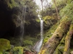
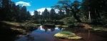
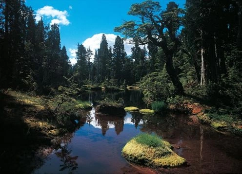
There are 3 lakes and 6 main rivers within the Park. These are the El Cabro lagoon (155 ha.) And the unexplored lakes (150 ha.) And Pinto Concha (475 ha.), The latter being the most visited tourist attraction in the Park. This lake increases its channel notably in winter due to the abundant rains that characterize this season, but also grows in summer due to the melting of snow from the high mountains that surround it.
The rivers are Río Negro, R. Blanco, R. Traidor, R. Esperanza, R. Del Este and R. Mariquita. The first one is born in the Pinto Concha lake by underground drainage and runs for 19 km until its outlet in the Hornopiren fjord. The R. Blanco basin is the largest in the Park (26,000 ha) and includes most of the highest mountains (over 2,000 meters high).
Wild flora:
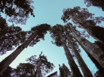
In the National Park a variety of characteristic communities of temperate rainforest ecosystems of southern Chile are represented, highlighting the following forest types: Alerce (Fitzroya cupressoides) 10,000 ha, Lenga (Nothofagus pumilio) 6,000 ha, Coigüe de Magallanes (N) betuloides) 3,000 ha and Evergreen (several tree species) 4,000 ha.
The Alerce was declared a National Monument in 1976 and since then it has been protected by Law (Supreme Decree No. 490), which prohibits the exploitation of live specimens, although it allows the commercial use of dead trees under strict State control (CONAF).
Wildlife:
It is estimated that 25 species of mammals, 123 birds, 9 amphibians and 1 reptile cohabit in the Hornopiren National Park, existing within those 18 species classified as threatened. Given that the administration of the Park is relatively new, there is still a great opportunity to complete these listings or make them more accurate through the development of scientific studies.
Among the largest animals that have been sighted by visitors are:
puma (Puma concolor),
pudú (Pudu pudu),
zorro chilla (Pseudalopex griseus),
carpintero negro (Campephilus magellanicus) and many other birds.
Tourist Information
Dependencies:
There is an office-refuge within the Park for the exclusive use of the park ranger (CONAF staff). It is located on the southwest side of Lake Pinto Concha and works in the summer months of January and February. The office offers information, guidance and support to visitors on any matter related to their stay in the Hornopiren National Park.
Although there are no other facilities for recreational use yet, the most extreme visitors can camp in a place near the shelter that has been cleared for this purpose and that has tables and benches. Those who are willing to do that must keep in mind that they will not find camping services of any kind, such as bathrooms, barbecue or drinking water.
Walking trails:
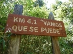
There are 2 official trails within the Park, which have periodic surveillance and are regularly maintained by CONAF. The first one starts at the sign to welcome the Park and travels 2.9 km (1 hour) through millennial larch forest to the southwestern edge of Lake Pinto Concha at 950 meters above sea level.
The second trail begins at this point and travels 3.6 km uphill (2 hours) through larch and lenga forests to the south slope of the Yates volcano at 1,500 meters high from where it is possible to appreciate a magnificent mountain landscape snowfall, native forests and lakes. This place can be reached during the summer (December to March) without the need of sophisticated mountain equipment and therefore can be enjoyed by any healthy and enthusiastic visitor.
Both trails are rustic and share the characteristics of having a low to medium slope and a mainly hardened earth floor, although in the mountainous part of the trail to the Yates volcano dominates the volcanic rock floor. This makes them strenuous and of some risk, so they are currently only recommended for experienced and healthy walkers.