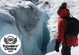
Icefields Parkway Self-Guided Driving Audio Tour
Embark on one of the most scenic drives on earth with this self-guided Icefield Parkway tour connecting Canada’s Jasper and Banff National Parks. Witness soaring mountain peaks, ancient glaciers, brilliant turquoise lakes, and much more as you cruise the Canadian Rockies. Dive into Indigenous history, spot diverse wildlife like moose and elk, and discover how this breathtaking landscape has formed and reformed over the eons. A tapestry of beauty and history awaits!
Purchase one tour per car, not per person. Gather your group and journey together!
After booking, you can check your email before downloading the Tour Guide App by Action, enter your unique password, and access your tour. The preceding steps require good internet/wifi access. Simply follow the audio instructions and the route from there.
New, extra validity — now, it’s yours for an entire year! Use multiple times over multiple trips!
Note: This isn't an entrance ticket. Before your visit, check opening hours.
ItineraryThis is a typical itinerary for this product
Stop At: Jasper Information Centre, 500 Connaught Drive, Jasper, Jasper National Park, Alberta T0E 1E0 Canada
Welcome to the Icefields Parkway! Get ready to experience Canada’s glorious stretch of road between two of its most famous National Parks: Jasper and Banff. You can reach the parkway from different locations, so make sure you’ve selected the correct starting point. This version of the tour begins in Jasper. To start from Lake Louise, which is near Banff, go back to Home and switch to the Lake Louise version
Note: This 135-mile-long tour covers the essentials of Icefields Parkway in 3-4 hours.
Duration: 10 minutes
Stop At: Jasper SkyTram, Whistlers Rd, Jasper, AB T0E 1E0, Canada
Coming up soon is the Jasper SkyTram, the highest and longest aerial tramway in Canada. The views from the top are simply unbeatable. In the 1940s, Whistler Mountain had already become a major magnet for skiers. Fans of the winter sport congregated on the perfect slopes every year to race each other down. But once at the bottom, they only had a limp tow rope to usher them up the mountain again. Because of the difficulty of the ascent, they never went all the way up the mountain!
Duration: 10 minutes
Stop At: Valley of the Five Lakes Trailhead, Valley of the Five Lakes, Jasper, AB T0E 1E0, Canada
Up ahead is the Valley of the Five Lakes Trailhead. The 3-mile moderately challenging hike takes about an hour and a half to complete and rewards hikers with some amazing scenery. The trail weaves past five pristine lakes. The lakes and ponds in Jasper and Banff are unlike those found anywhere else. That’s because of their unbelievable turquoise and blue hues that seem like something out of a heavily photoshopped postcard. But it’s real! And we have glaciers to thank.
Duration: 10 minutes
Stop At: Athabasca Pass Lookout, Ab-93, Jasper, Jasper National Park, Alberta T0E 1E0 Canada
Right around the bend is the Athabasca Pass Lookout, one of the best viewpoints at this part of the Parkway. From here, you’ll get a great look at the South Jasper Mountain Range. The most prominent peak, which will be dead ahead from the perspective of the lookout, is Mount Edith Cavell, standing 11,033 feet in height.
Duration: 10 minutes
Stop At: Horseshoe Lake, AB T4G 0M4, Canada
In just a moment, we’ll pass by Horseshoe Lake. This U-shaped body of water has become quite popular among thrillseekers thanks to the sheer rock faces surrounding it. On any given day, you might approach to find a group of people standing at the edge, bodies jittery with adrenaline. They stare down…and down and down toward the bottom —75 feet in total! Then, they take the leap of faith. The wind soars as they drop, then HIT the freezing water that shocks their system. Then they pop back up, ready to do it all over again!
Duration: 10 minutes
Stop At: Athabasca Falls, Hwy 93, Jasper, Jasper National Park, Alberta T0E 1E0 Canada
Coming up ahead is Athabasca Falls, a 75-foot waterfall plunging into a canyon. During the last Ice Age over 100,000 years ago, a glacier in this region receded enough to allow the Athabasca River to flow freely through the pass. The pass eventually deepened and widened, becoming the canyon it is today.
Duration: 10 minutes
Stop At: Mount Kerkeslin, Improvement District No. 12, AB T0E 0E0, Canada
That towering peak off to our left is Mount Kerkeslin, which stands at 9,790 feet. This is the highest peak in the Maligne Range, and posed a real challenge for early explorers of this region.
Duration: 10 minutes
Stop At: Goats & Glacier Lookout, Improvement District No. 12, AB T0E 1E0, Canada
This vista overlooks the Athabasca River and Fryatt Mountain Range. Glaciers can be seen high up on those mountains, but where do the goats come in- Well, the cliff on which this overlook is perched is dense in all kinds of minerals, including salt. And mountain goats just can’t get enough of the stuff! Visitors often see them wandering up here, licking away at the rocks!
Duration: 10 minutes
Stop At: Mount Christie, Improvement District No. 12, AB T0E 1E0, Canada
The peak directly to our right, just before that mountain pass, is Mount Christie. It stands just over 10,180 feet tall. The peak gets its name from James Hector, the explorer who also named Mount Kerkeslin. Hector named the mountain after a man who hosted him during his expedition across the Rockies: William Joseph Christie.
Duration: 10 minutes
Stop At: Honeymoon Lake, Improvement District No. 12, AB T0E 0E0, Canada
This romantically-titled body of water offers a lovely view of reflected mountains in the Maligne Range. You might even see some folks paddling canoes on the water.
Duration: 10 minutes
Stop At: Sunwapta Falls, Improvement District No. 12, AB T0E 1E0, Canada
The trail for Sunwapta Falls is coming up soon. This easy 2-mile trail takes just over an hour and features a great view of a wilderness waterfall. Fed by the Athabasca Glacier, Sunwapta Falls plummets 60 feet over the cliff edge. Sunwapta is the Stoney-Nakoda word for “turbulent water,” which makes sense when you see the falls!
Duration: 10 minutes
Stop At: Endless Chain Ridge, Improvement District No. 12, AB T0E 0E0, Canada
That ridge up ahead and slightly to our left is the Endless Chain Ridge. Spanning more than 9,000 feet, this ridge is a collection of craggy peaks forged in the Jurassic period, about 200 million years ago. Volcanic pressure beneath the earth’s crust forced this rock upward about 75 million years ago, forming the ridge we see today.
Duration: 10 minutes
Stop At: Poboktan creek trail parking, Improvement District No. 12, AB T0E 0E0, Canada
In a moment, we’ll see parking for the Poboktan Creek Trail, though we probably won’t want to hike it ourselves. Why’s that, you ask- Because it’s 24 miles long and takes an average of four days to complete!
Duration: 10 minutes
Stop At: Quartzite Boulder Field, AB-93, Jasper, AB T0E 1E0, Canada
In just a minute, we’re going to pass an attraction that… doesn’t look much like an attraction. In fact, it just looks like a pile of rocks! But this pile of rocks tells a fascinating story about the history of this landscape.
Duration: 10 minutes
Stop At: Beauty Creek, Improvement District No. 12, AB T0E 0E0, Canada
We’re driving alongside Beauty Creek, a pure and clear glacial lake fed by meltwater. If one were to follow this creek a couple of miles into the wilderness, they’d arrive at Stanley Falls!, which plunges 40 feet into a blue pool below. Seven other cascades lead to Stanley Falls, and feature something very peculiar that doesn’t happen in many places. In colder months, these waterfalls don’t just dry up. Instead, they become sheer sheets of ice!
Duration: 10 minutes
Stop At: Stutfield Glacier Viewpoint, Improvement District No. 12, AB T0E 0E0, Canada
Coming up is the Stutfield Glacier Viewpoint, where we can see a huge glacier directly from the parkway! The icy giant stretches 3,000 feet over the cliff face, where you can glimpse a set of double icefalls. These are places where the glacial bed steepens and the ice flows faster than in other areas. In turn, they create deep crevasses that pose a major hazard for climbers.
Duration: 10 minutes
Stop At: Tangle Creek Falls, AB, Icefields Pkwy, Improvement District No. 12, AB T0E 0E0, Canada
Just ahead is Tangle Creek Falls, a magnificent 90-foot cascade alongside the parkway. With its spray dampening the road, the waterfall is impossible to miss! Mary Schäffer Warren, the same woman who named Endless Chain Ridge, also gave Tangle Creek its name! But the eager mountaineer-turned-surveyor rarely traveled alone. Many of her journeys were guided by Samson Beaver, a Stoney-Nakoda man.
Duration: 10 minutes
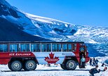
Stop At: Columbia Icefield Skywalk, The Icefields Parkway Columbia Icefield Glacier Discovery Centre, Jasper National Park, Alberta T0E 1E0 Canada
Have you ever wanted to walk on air- The Columbia Icefield Skywalk offers that sensation. It’s a walking trail with a glass floor that snakes along the cliffside. The clear structure juts out 100 feet across the Sunwapta Valley. If you don’t mind heights, you can look down past your shoes at the snowy expanse more than 900 feet below.
Duration: 10 minutes
Stop At: Mount Kitchener, Improvement District No. 12, AB T0E 1E0, Canada
See the tallest peak off to our right- That’s Mount Kitchener, standing at 11,499 feet. It gets its name from Horatio Kitchener, a British Earl who served as an officer during the first World War. Kitchener died in 1916 when his ship struck a mine and sank en route to Russia. As soon as word of his death reached Canada, officials renamed this mountain in his honor.
Duration: 10 minutes
Stop At: Toe of the Athabasca Glacier Trailhead, Glacier Rd, Jasper, AB T0E 1E0, Canada
If you want an up-close-and-personal look at the glaciers I’ve been talking about, this is a must-do. At just over one mile, this moderate hike offers some of the best views of the Athabasca Glacier, one of the most noteworthy in the Columbia Icefield.
Duration: 10 minutes
Stop At: Wilcox Pass Trailhead, Jasper, AB T0E 0E0, Canada
Just ahead is the Wilcox Pass Trail. This challenging 7-mile hike isn’t for the faint of heart. But don’t worry if you’re not up for the whole thing! Most visitors opt to hike a little over a mile to reach a fantastic viewpoint before turning back. That viewpoint overlooks a unique geographical feature at the crossroads of Jasper and Banff: Mount Snow Dome.
Duration: 10 minutes
Stop At: Parker Ridge Trail, Improvement District No. 9, AB T0L, Canada
The Parker Ridge Trail is coming up momentarily. It leads to a 4-mile hike for those seeking a challenging route. You’ll need to set aside a little over two hours to experience the alpine meadows and panoramic views. It also features glimpses of the Columbia Icefield and fresh perspective on the famous turquoise lakes in the area.
Duration: 10 minutes
Stop At: Panther Falls, Improvement District No. 9, AB T0M 2H0, Canada
Coming up next is Panther Falls. An easy 1.5-mile hike through the forest leads to this 210-foot cascade. It only takes about 30 minutes and is well worth the trek! If you want to keep going, you can hike another mile to Bridal Veil, which is five times the size of Panther Falls! It’s a two-for-one waterfall extravaganza!
Duration: 10 minutes
Stop At: Weeping Wall viewpoint, Alberta, 93 Icefields Pkwy, Improvement District No. 9, AB T0L, Canada
Just ahead is the Weeping Wall Viewpoint, a set of 900-foot high cliffs. The Weeping Wall is almost like a part-time waterfall. Under just the right conditions the cliffside begins to weep—or leak water. The will-it-or-won’t-it fall dynamic comes from the natural springs at the top, which may either swell or trickle depending on the time of year.
Duration: 10 minutes
Stop At: Mount Coleman, Improvement District No. 9, AB T0M 2H0, Canada
The peak off to our left is Mount Coleman, standing at an impressive 10,285 feet. But if you asked early explorers, this wasn’t even close to the tallest peak in the region.
Duration: 10 minutes
Stop At: HI Rampart Creek Wilderness Hostel, Banff National Park Of Canada, AB-93, Banff, AB T1L 1B3, Canada
We’re about to pass the HI Rampart Creek Wilderness Hostel. This humble lodging dates back to a big change in tourism that started unfolding almost 100 years ago.
Duration: 10 minutes
Stop At: Saskatchewan River Crossing, Highway 93 and Highway 11 Improvement District No. 9, Lake Louise, Banff National Park, Alberta Canada
Long before the Icefields Parkway existed, crossing the river looked a little different. Imagine a long plank of wood drifting across the river. A horse and carriage rest on the surface, waiting to be directed to the other side. The year is 1882 and the man behind the operation is the well-liked John Walter.
Duration: 10 minutes
Stop At: Howse River, Improvement District No. 9, AB, Canada
Turn into the parking area just ahead for Howse Pass Viewpoint, featuring incredible views of the river and the mountains beyond. This is a must-see!
Duration: 10 minutes
Stop At: Mistaya Canyon Trail Head, Saskatchewan River Crossing, AB T0L, Canada
Coming up ahead is the Mistaya Canyon Trailhead. This moderate, 1.5-mile hike takes about 40 minutes and leads to the bottom of the deep gorge flowing with water.
Duration: 10 minutes
Stop At: Mount Chephren, Improvement District No. 9, AB T0L, Canada
Its 10,715-foot peak brushes the sky and provides pro-climbers with an extreme challenge. Due its angular slopes, Chepren originally bore the name Pyramid Mountain. But another summit in the area already had the same title, so the park settled for christening it after an ancient Egyptian Pharaoh. Specifically, a ruler responsible for the second largest pyramid in Giza! Certainly a fitting name for the mountain.
Duration: 10 minutes
Stop At: Waterfowl Lake Viewpoint, Improvement District No. 9, AB T0L, Canada
It’s impossible to miss the gorgeous Waterfowl Lake coming up ahead, as well as the viewpoint overlooking it. Hip to hip with the parkway, you won’t even need to leave your car to glimpse this emerald body of water. Lakes like this one became hotspots for a countercultural movement sweeping across the country in the 1960s. They were the hippies!
Duration: 5 minutes
Stop At: Mt Patterson Glacier, Improvement District No. 9, AB T0L, Canada
Off to our right stands Mount Patterson, home to one of the park’s many glaciers. This is the Snowbird Glacier. It gets its name from the way it flows down Mount Patterson. Doesn’t it look a little like the glacier has outstretched wings-
Duration: 10 minutes
Stop At: Peyto Lake, Improvement District No. 9, AB T0L, Canada
Off to our right is Peyto Lake. The glacier-fed body of water promises a bright turquoise color in the foothills of the Waputik Range. If you’d like to visit the lake, keep an eye out for the side road coming up in just a minute. It leads to an overlook above the lake and a 2-mile trail around the lake’s circumference.
Duration: 5 minutes
Stop At: Bow Lake, Improvement District No. 9, AB T0L, Canada
We’re now approaching Bow Lake. Its stunning blue waters reflect the craggy rocks of Mount Jimmy Simpson, looming directly to our right. The mountain gets its name from an English immigrant of the same name.
Duration: 5 minutes
Stop At: Crowfoot Glacier Viewpoint, Alberta, 93 Icefields Pkwy, Improvement District No. 9, AB T0L, Canada
Coming up in a moment is the Crowfoot Glacier Viewpoint. The massive block of ice is still inspiring, despite all it's been through… The glacier has been receding since the Ice Age and has lost one of three lobes. Those lobes, or protruding thumbs of ice, once made the ice chunk look like a crow’s foot.
Duration: 5 minutes
Stop At: Wapta Icefield, Improvement District No. 9, AB T0L, Canada
The Wapta Ice Field gets its name from thehome to some miraculous marine d Stoney-Nakoda word for “running water.” And it has been iscoveries.
Duration: 5 minutes
Stop At: Hector Lake Viewpoint, Icefields Pkwy, Improvement District No. 9, AB T0L, Canada
If you can’t get enough of Banff’s dazzling waters, the upcoming Hector Lake Viewpoint is worth the stop. This pristine glacial lake sits directly beneath Lilliput Mountain and Mount Balfour, and is a hugely popular spot for photographers.
Duration: 5 minutes
Stop At: Lake Louise, Lake Louise, Banff National Park, Alberta
This brings us to the end of our tour. To reach Lake Louise, just keep driving straight for another 5-10 minutes. I hope you’ve enjoyed your journey across the Icefields Parkway, hearing about everything from Jasper’s geological wonders to Banff’s wild mountaineers!
Duration: 5 minutes
Informacion Adicional
"Not wheelchair accessible"
"Near public transportation"
"Most travelers can participate"
"How to access: Once you book a tour, you’ll get a confirmation email and an instructions email. Follow the instructions right away: • Download the app • Enter the password • Download the tour • MUST DO while in strong wifi/cellular"
"How to start the tour: Once onsite, open the Action's Tour Guide App: • If there is just one tour, launch it. • If there are multiple tour versions, launch the one with your planned starting point and direction. • Go to the starting point. (Note: no one will meet you at the start. This tour is self-guided). • The audio will begin automatically at the starting point. If you face audio issues, visit the FAQ. • Stick to the tour route & speed limit for the best experience."
"Amazing savings: • Driving Tours: Save money by purchasing a single tour for the entire vehicle, avoiding individual fees per person like on a bus tour. Connect your phone to the car speakers to share the audio."
"Flexibility and Convenience: • Use the tour app anytime, on any day, and over multiple days. There's no expiration, making it perfect for revisiting on future trips. • Start and pause the tour at your leisure, accommodating breaks and side excursions without the pressure of keeping up with a group."
"Comprehensive Tour Experience: •The app provides a full itinerary, travel tips, narrated audio stories, scripts, images, videos, and recommendations for additional activities. • Enjoy a private experience without the crowds, ideal for personalized stops and photo opportunities."
"Ease of Use and Accessibility: • The app is hands-free and activates stories via GPS, offering support through call, chat, or email. • There is no need for a continuous cell or Wi-Fi connection as the GPS map works offline."
"Memorable Keepsakes: • Utilize the app’s images to create a photo book or share on social media, ensuring you have high-quality, crowd-free memories from your trip."
"Preparation: • After booking, download the app and the tour using a strong Wi-Fi connection. • Review the tour at home before your trip for a better experience."
"Starting the Tour: • Open the app upon arrival at your destination. • Select the appropriate tour based on your starting point. • Head to the starting location; the audio will begin automatically. • Follow the suggested route and adhere to the speed limit for an optimal experience. • By following these instructions and taking advantage of the app's features, users can enjoy a personalized, flexible, and in-depth exploration of their destination at their own pace and convenience."
"This is a private tour/activity. Only your group will participate"
"Confirmation will be received at time of booking"
Start Time:
Icefields Parkway Self-Guided Driving Audio Tour
7/21/2022 - 4/29/2025| Monday - Sunday : | 06:00 AM - 06:30 PM |
Duration: 5 To 6 Hours
Start location: Jasper Park Information Center, 500 Connaught Dr, Jasper, AB T0E 1E0, Canada
Cancellations and refunds:
For a full refund, cancel at least 24 hours in advance of the start time of the experience.