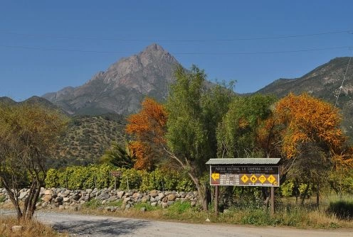
La Campana National Park. Olmue - CHILE
Direccion:
Hijuelas, Valparaiso La Campana National Park was created on October 17, 1967 with an area of 8,000 hectares divided into three sectors: Hail 972 ha, has Cajon Grande 1588 (both located in the commune of Olmue) and Palmas de Ocoa 5440 ha. (in the commune of Hijuelas). It is administered by CONAF and in 1985 was declared a Biosphere Reserve.
Location:
In the Coastal Range of central Chile, south of the Aconcagua Valley, between latitudes 32 ? 55 - 33 ? 01 latitude south and 71 ? 09 - 71 ? 01 west longitude, Valparaiso Region, Chile. Its altitude ranges from 400 to 2222 m.s.n.m.
Distances and access:
From? |
to Granizo |
to Ocoa? |
Santiago |
160 km. |
112 km.? |
Valpara?so |
60?km. |
90 km. |
Quillota |
29?km. |
37 km. |
Cajon Grande Sector: It has the same pathways that the sector of Hail, but the whereabouts 40 of Hail Avenue, there is a bifurcation. By taking the right hand side (going 3 km.) Offers access to this sector. There is public transportation that leaves 1 km from the gatehouse to the sector.
Palmas de Ocoa Sector: Access is on Route 5 north, at Km. 98 in the direction of the town of Ocoa. Then take Route 304 in F direction to the sector (14 km. Approx., From the road). There is public transport from La Calera to Rabuco, remaining 6 km of access.
Granizo: From Olmu? Limache and is accessed by Route 62 The Orozco and / or Core South Avenida routes linking with Eastman, which rises to hail Sector. The public transportation reaches the location 45, from where you must walk 1 km. approximately up to the entrance booth. Also accessible on Route 5 North or The Sleeping costs via Til Til. Climate:
Mediterranean, rainy winters (May to August) 480 mm approx. and a prolonged dry period (September to April), with 120 mm approx.
Tourist Information
Administration:
You are at the location 43 of Hail Avenue No. 9137 in the commune of Olmu?. Phone / Fax (33) 441342 / 442922 and phone Hail Sector (33) 443067.
Visiting hours: Saturday to Thursday from 09:00 to 17:30 hrs.
Friday from 09:00 to 16:30 hrs.
Dependencies:
Hail Sector: This sector is enabled with 23 picnic sites, stoves, tables, benches, restrooms and cold showers. It is the only sector in which you can access the top of Cerro La Campana.
Cajon Grande Sector: In this we can find 23 sites for picnic, tables, benches, bathrooms and showers with cold water. It is characterized by its natural pools, highlighting among others the Poza del Coipo.
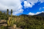
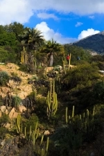
Palmas de Ocoa Sector: The sector has 32 picnic sites, stoves, tables, benches and restrooms. It is characterized by the highest concentration of Palma Chilena (Jubaea), with 62,000 copies Vulnerable species and one of the wide distribution of the world s southernmost continent.
Note: (1) The three sectors with chlorinated water, "No drinking", as suggested boil before consuming it or bring bottled water.
(2) No single sector has electricity in the camp sites.
Trails:
Granizo
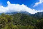
Sendero Andinista: ?nica ruta que conduce a la cima del Cerro La Campana, de 7 km. extension, which can travel at approx. 8 hours (round trip to the starting point). Here you can see flora and fauna, is a natural viewpoint Olmu? Valley, Andes Mountains, and with good weather, the Pacific Ocean. As legislation visitors wishing to summit the peak is higher hours until 10:00 am.
Sendero Peumos-Portezuelo Ocoa: 5.5 km, suitable for observation of flora and fauna, viewpoint Ocoa Valley and Cajon Grande, with journey times from 2:30 to 3 hours (one way). Path that connects internally to the three areas of the park.
Cajon Grande Sector
Plateaux Trail: 4.2 km, being able to go in 2:30 hrs. (One way), observation of flora and fauna, viewpoint Olmu? Valley and Quebrada Palmas de Alvarado.
Path Portezuelo Ocoa: 4.4 km., One can see flora and fauna. Finding copies of Santiago Robles (Nothofagus macrocarpa) during most of the trail. Since this protected wildlife area on the northern boundary (north) of the species distribution in South America.
Sector Palmas de Ocoa
Sendero La Cascada: 6 km long, reaches a viewpoint where you can see a waterfall about 30 meters, which gives its name to the path.
The Jumbled Path: gets to the heart of Palmar de Ocoa, connects to the sectors Olmu? Cajon Grande or hail, depending on the crossing, whichever travel about 12 km at an estimated time of 5 hours.